")
")
")
")
About Čoka Municipality
The municipality of Čoka (Opština Čoka) is situated on the left bank of the Tisa river in the northern part of the autonomous province of Vojvodina, Serbia. It is 180 km from Belgrade, 100 km from Novi Sad, 105 km from Timisoara and 60 km from Szeged (Hungary).
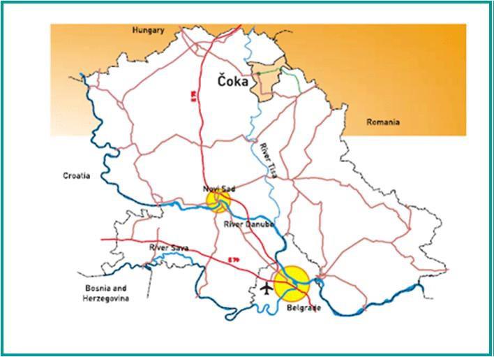
Photo 1. Position of the municipality of Čoka
In the north it is bordered by Novi Knezevac, Senta in the west and Ada in the southwest, in the east with Kikinda and the state border with Romania. The territory of the commune has an area of 321 km2.
Municipality of Čoka has the current form from September 1, 1955 and includes eight settlements: Čoka, Ostojićevo, Padej, Sanad, Jazovo, Vrbica, Crna Bara and Banatski Monoštor.
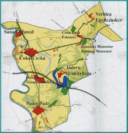
Photo 2. Municipality of Čoka - component settlements
HISTORIC
Banat, like the entire Pannonian Plain, was inhabited since the prehistoric age, most likely since the Bronze Age. Over times, on this territory lived The Goths, the Huns, the Avars, the Tartars, the Turks, the Serbs, the Hungarians and the Romanians. Of all these peoples, we can say that only Serbs and Hungarians have remained, being the oldest inhabitants. The rest of the peoples disappeared or were displaced, assimilated or came later, after the retreat of the Turks in 1718.
The first documentary attestation dates back to 1247, under the name of Čaka. At that time, because of the marshland, the settlements around Čoka frequently changed their position, only this has remained, being located on a higher, free flood land.
Since the Middle Ages, Čoka had several rulers, being conquered by the Huns and Turks, bought by noble, wealthy families. During the Turkish occupation, trade has developed, new crops such as corn have been introduced and commercial routes have been created.
In 1779, Čoka was part of the Old Banat, Torontal County, owned by Lerinc Marciban, who bought this locality at the first open auction in Vienna with the amount of 95,500 forints.
Starting with 1782, Germans, Hungarians, Romanians, Slovaks, Poles and others have settled in this part of the Banat.
The first school was founded in 1773, with teaching in Serbian language, and in 1800 was founded another school with teaching Hungarian language.
At the end of the nineteenth century, Artur brothers and Carol Lederer became the owners, Čoka reaching the peak of economic development under their leadership.
The Lederer Brothers possessions numbered 9500 juggers, growing sugar, tobacco, hemp, sorghum, vegetables, grapevine, cereals, etc. The Lederer family home was one of the most famous of the ancient Banat and interwar Yugoslavia. They were also famous for their wine and flower production.
Due to the global economic crisis of 1934, the sale of pigs has fallen sharply, so Lederer decides to build a slaughterhouse, which has led to the development of the meat industry, for which it has been known for a long time.
With the occupying of the Banat by the Germans in 1941, part of the properties in Čoka were taken over by Hermann Göring, and all the food produced in the area being taken to the front.
In 1945, all of Lederer's fortune is confiscated, the industry is nationalized, the old order disappears, and a new world emerges.
POPULATION
According to the 2011 census, 11,388 inhabitants lived in the village of Čoka, 2444 persons less than in 2002.
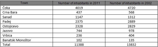
From the statistical data of 2014, it appears that the number of inhabitants is 11,081. The causes of this demographic decline are low birth rates and the migration of young people due to current economic conditions.
As for the ethnic structure, the Hungarians predominate (51.56%), followed by Serbs (37.63%), Rroms (2.43%), Yugoslavs (1.64%), Slovaks (1.45%). For political reasons, the Poles who lived mostly in Ostojićevo declared themselves Slovak. The localities with a majority Hungarian population are Banatski Monoštor, Vrbica, Jazovo, Padej and Čoka. Ostojicevo, Sanad has a majority Serb population, and the Hungarians predominate in Crna Bara.